
.jpg)


Planned Launch Date: 2022
The NASA-ISRO SAR (NISAR) Mission will measure Earth’s changing ecosystems, dynamic surfaces, and ice masses providing information about biomass, natural hazards, sea level rise, and groundwater, and will support a host of other applications.
NISAR will observe Earth’s land and ice-covered surfaces globally with 12-day regularity on ascending and descending passes, sampling Earth on average every 6 days for a baseline 3-year mission.
What is SAR?
Synthetic aperture radar (SAR) refers to a technique for producing fine-resolution images from a resolution-limited radar system. It requires that the radar be moving in a straight line, either on an airplane or, as in the case of NISAR, orbiting in space.How does it work ?
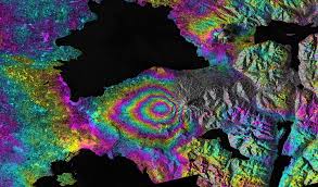
The basic principle of any imaging radar is to emit an electromagnetic signal (which travels at the speed of light) toward a surface and record the amount of signal that bounces/echoes back, or “backscatters,” and its time delay. The resulting radar imagery is built up from the strength and time delay of the returned signal, which depends primarily on the roughness and electrical conducting properties of the observed surface and its distance from the orbiting radar.The NISAR spacecraft will accommodate two fully capable synthetic aperture radar instruments: NASA’s 24 cm wavelength L-band Synthetic Aperture Radar (L-SAR) and a 10 cm wavelength S-band Synthetic Aperture Radar (S-SAR) provided by ISRO. NISAR has a ~ 240 km swath, 7 m resolution along track and 2-8 m resolution cross-track (depending on mode).
Why is it unique ?
NISAR will be the first radar of its kind in space to systematically map Earth, using two different radar frequencies (L-band and S-band) to measure changes in our planet's surface less than a centimeter across.SAR techniques take advantage of the fact that the radar is moving in orbit to synthesize a virtual 10-km-long antenna from the physical 10-m antenna in the direction of flight. As the radar moves along its path, it sweeps the antenna’s footprint across the ground while continuously transmitting pulses – short signal bursts separated by time – and receiving the echoes of the returned pulses.
In this way, SAR beats the resolution limits of what can physically be put in space to provide images and science of much higher quality than would be possible if the antenna size was used as is.
